| |
|
The political economy of development |
|
| Home- Themes- Reports- Statistics/Search- Lecture notes/News- People's Century- Puro Chile- Mapuche |
| Make your work easier and more efficient installing the rrojasdatabank toolbar ( you can customize it ) in your browser. |
|
| World indicators on the environment | World Energy Statistics - Time Series | Economic inequality |
|
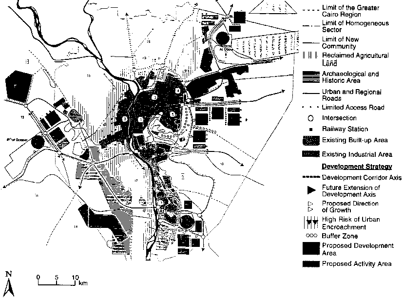
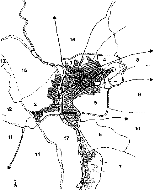
The urban challenge in Africa: Growth and management of its large cities Edited by Carole Rakodi - United Nations University Press - TOKYO - NEW YORK - PARIS - ® The United Nations University, 1997 Transportation and infrastructure Although the road network represents nearly 25 per cent of the total GCR area, its practical capacity is inadequate owing to many problems. Lack of maintenance, poor driving habits, low vehicle occupancy, bottlenecks, and lack of parking lots and garages are among the major problems that decrease the efficiency of the network. In 1983 more than 530,000 vehicles were on the road. Owing to the sharp increase in car ownership in the GCR in the past decade, this figure has now doubled to reach more than 1 million vehicles. Amongst the most important bottlenecks are the six bridges over the Nile that link Cairo and Giza sections and are overloaded during the rush hour. Mass transportation is owned and operated by the public sector and is, by any standards, overloaded. In response to this problem, privately owned passenger vans have begun to function all over the GCR. The General Organization for Water in the GCR provides almost 3 million m│ of potable water per day. This amount is sufficient by international standards to supply the population. However, owing to the lack of maintenance of pipelines, equipment, and fittings, more than 25 per cent of this capacity is lost or wasted. The water network is old and pipe diameters are small, adding more problems to the distribution of water to many areas of the city. The situation with respect to the sewer network is even worse, even in districts connected to the system. Because of the sharp increase in population densities, the discharge in many districts of the GCR far exceeds the capacity of the sewerage system. This causes frequent overflows and represents a dangerous source of pollution. In 1994, 14 per cent of the buildings in the Cairo and Giza sections were not connected to any infrastructure system. Of the remaining 86 per cent, 9 per cent are still not connected to the water system, 8 per cent have no electricity, and 38 per cent are unconnected to sewage disposal networks. Solid waste disposal is a major problem in Cairo, where more than 3,000 tons of solid waste is produced every day: 60 per cent is collected by private contractors and the remaining 40 per cent by local municipalities. Informal sector operators based in "refuse settlements" pay for the rights to collect refuse from wealthier parts of the city, using female household labour to sort it into recyclable waste for sale, organic waste for animal fodder, and unusable waste, which is burnt. An effective system, it results in very poor environmental conditions in the settlements concerned (Findlay, 1994). However, owing to the increased volume of solid waste and the geographical expansion of the city, neither private contractors nor the municipalities are able to keep up with the need. Problems of traffic congestion and inadequate services have combined to increase environmental pollution. High levels of air pollution, due to suspended particulate matter and lead generated by traffic and industry (especially cement manufacture), are exacerbated by wind-blown dust (WHO/UNEP, 1992). Social problems and inequality Wage jobs in the formal sector have not kept pace with demand. As a result, the informal sector, which it was hoped would diminish over time, has shown clear signs of expansion. Levels of unemployment, real and disguised, have risen sharply, particularly during the past decade. Interclass and inter-sector disparities have widened over time to add a new dimension to the polarization process, despite protests by the urban poor and, increasingly, the lower rungs of the middle classes. Data on income distribution in Egypt are very scarce. The only available figures are from a series of three consumer budget surveys conducted by the Central Agency for Population Mobilization and Statistics (CAPMAS) in 1958, 1964, and 1974. The 1974 surveys showed that the share of the top 20 per cent of the population was around 47 per cent of total income, while the share of the lowest 40 per cent was 17 per cent. A later study by the World Bank, in 1980, showed that the share of the top 5 per cent of the population had increased from 17 per cent of the national income in the late 1960s to 27 per cent in the late 1970s; and the share of the lowest 20 per cent had decreased from 7 per cent to 5 per cent during the same period (Abdel Khalek and Tignor, 1982). In addition, the share of wages in national income, which decreased from 50 per cent in 1967 to less than 34 per cent in 1986, indicates the shift towards an increasingly unequal distribution of wealth. Social problems, such as lack of safety, illiteracy, and crime, have appeared in many parts of this mega-city, affecting both rich and poor areas. It has become evident, during recent decades, that government institutions are not able to cope properly with the ever-increasing rate of growth of Cairo and to manage it. Policies, plans, and future prospects National and Greater Cairo Region plans Such concentrations of population, economic activities, wealth, and power have led to serious urban problems, resulting in several attempts since 1960 to manage and reorganize the growth of the GCR and to decentralize population and activities. At the national level, the country was divided into eight homogeneous planning regions in 1975, with the aim of developing peripheral regions in order to absorb the additional expected growth of the urbanized areas. In 1982, a national urban policy study identified several goals for the future planning of the GCR (Advisory Committee for Reconstruction, 1982). First, it was suggested that Cairo's urban growth be redirected from an essentially north-south axis to an east-west orientation on vacant desert areas in proximity to the current built-up area. Secondly, it was recommended that the deconcentration of central Cairo should be pursued through the establishment of secondary and tertiary commercial, financial, industrial, and administrative centres. Thirdly, it suggested policies to promote an improvement in the general quality of life. Fourthly, it advocated the creation of appropriate instruments of governance aiming at guiding and controlling an integrated set of spatial, economic, social, and financial programmes. At the city level, a master plan was formulated in 1970 incorporating two major concepts on which it recommended that the future management of the region be based (Ministry of Housing, 1970). First, it was suggested that a ring road surrounding the existing built-up area be constructed to control its growth and stop the invasion of agricultural areas. Secondly, it was recommended that self-sufficient new communities be established at suitable distances from the city to attract additional expected growth. Although the ideas of this plan were not fully implemented in the following years, they formed the basis for policies adopted in the 1970s and for the structural plan of 1983 (fig. 4.8), which remains the major guide for the urban development of the GCR to date. In the 1983 plan, demographic studies produced estimates that the population of the GCR would increase from 6,700,000 in 1977 to 9,660,000 in 1982 and 16,500,000 by the year 2000 (table 4.6; GOPP, 1983), in addition to 1,400,000 people in surrounding rural areas that it expected to be included in the region by that date. This population would be absorbed both within and outside the existing built-up area. Within the existing area it was considered that population could be accommodated by incremental development, in proposed major housing projects, on vacant desert land inside the ring road to the north and east, and in pockets of agricultural land and peripheral areas to the north, east, and west (fig. 4.8). This, it was suggested, will require a restructuring of the metropolitan region using the concept of "homogeneous sectors", which will be discussed below. Table 4.6 shows the expected distribution of the population by the year 2000. It was estimated that an additional 5,055,000 could be accommodated within the built-up area and on marginal arable land. Secondly, the rest of the population will be accommodated outside the built-up area through the establishment of new satellite or independent communities on major radial axes and 10 smaller settlements adjacent to the ring road. It was estimated that 4,745,000 inhabitants would be absorbed in these communities and settlements by the year 2000. The concept of homogeneous sectors The concept of "homogeneous sectors" was suggested in the 1983 plan as a basis for reorganizing the existing built-up area in Cairo. It has since been developed to encompass the whole area of the GCR. It was suggested that, as Cairo is becoming too big to be managed as one unit and from a single core, it should be subdivided into smaller units within which development could be directed to ensure better living conditions, particularly in terms of the provision of job opportunities and the upgrading of existing service standards. Homogeneity in each sector was defined as meaning an equal distribution of services and access to jobs among its residents. However, it was envisaged that some sectors could specialize in particular functions, such as administration, commercial services, small-scale industries and handicrafts, or heavy industries. Such differentiation could, it was thought, strengthen the sector's identity. It was suggested that the GCR could be divided into 17 homogeneous sectors, as shown in figure 4.9, according to the following criteria:
Fig. 4.8 The Greater Cairo Region Structural Plan, 1983 (Source: GOPP, 1983)
Table 4.6 Distribution of population according to homogeneous sectors and directional growth areas, 1977-2000 (population in '000)
Fig. 4.9 Homogeneous sectors as defined in the 1983 Greater Cairo Region Structural Plan (Source: GOPP, 1983)
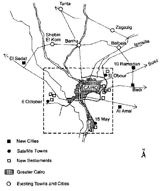
The new cities, satellite or independent, were intended to be developed as growth centres in order to attract economic activities and population from the core region. The cities are situated along the major regional radials to tie the GCR to other economic regions such as Suez, Ismailia, and Alexandria. Ten new settlements were suggested, primarily as an alternative to squatter and informal areas encroaching on agricultural land. These settlements were intended to be separate from the existing built-up area and to provide development affordable to the squatter population. Their size is intended to be large enough to guarantee an adequate level of self-sufficiency in terms of employment and services. It was hoped that the private sector would be the primary investor in these settlements, in order not to compete for public investment with the new towns. Finally, these settlements were to be located near existing labour pools in order to attract employment in the short and medium term. Figure 4.10 shows the proposed axes of development and the location of proposed new cities and settlements. The present situation The structural plan of 1983 was revised in 1991 (GOPP, 1991). New data showed a decline in the rate of growth in the city centre in favour of the middle and outer urban rings, particularly to the west. In the 1970s, most of this outer growth had taken place on agricultural land, indicating the urgency of providing desert land for urban expansion. However, the construction of new towns in the 1980s directed most of the urban growth to desert lands. The 1991 plan showed that encroachment on agricultural land decreased from 590 ha in 1980 to just under 150 ha in 1989. This was mainly due to sharp increases in land prices, declining purchasing power, and stringent legal controls. In addition to the six new cities and satellite towns that have been established (10 Ramadan, El-Sadat, Badr, 6 October, 15 May, and El-Obour), ten new settlements along the ring road have been started (table 4.7). The population capacity of the new settlements has been revised upwards to 5,382,000 from the 1983 estimate of 4,745,000. However, implementation is well short of that intended, and by 1994 only 448,850 people were living in the settlements (8.3 per cent of the planned population). Figures for the individual towns are given in table 4.7, although the resident population figures given in this table should be treated with care because an appreciable proportion of the population have taken housing units for speculative purposes and do not live in these cities. Only 7,346 housing units have been finished in new settlements, with almost 23,000 units in the construction phase, but finished units are not yet occupied for lack of infrastructure and services. Fig. 4.10 Distribution of new cities, satellite towns, and new settlements around the Greater Cairo Region (Source: GOPP, 1983)
Table 4.7 New towns occupancy in 1994 compared with year 2000 capacity
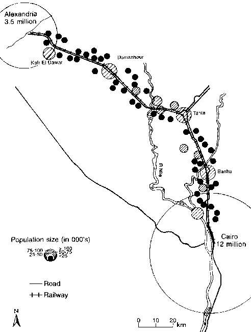
Many infrastructure and transportation projects have been implemented in the GCR: parts of the ring road have been finished; the first line of the metro between El Marg and Helwan has been completed; two major water treatment plants with a capacity of 1 million m│ per day have been constructed; and extensions to Cairo airport and the wholesale market in El-Obour have been completed. Other major projects are under way, such as the extension of sewage collection networks, the second line of the metro, a second wholesale market in 6 October city, and thousands of low-cost housing units in the new cities and settlements. However, the GCR is still facing serious urban problems in terms of a lack of job opportunities; informal and illegal expansion of the built-up area; deterioration of the housing stock; and social, health, and environmental problems. It has become very evident that the major impediment to the implementation of planned projects is mismanagement and lack of sectoral and geographic integration. The GCR is still managed by three different governors (in Cairo, Qalyubia, and Giza sections), each having their own authority, local departments, and resources. At the same time, some facilities and services, such as planning, transportation, water supply, and sewage disposal, are administered by regional authorities. These local and regional institutions are not integrated and coordination of policy and implementation is poor. In addition, sectoral ministries, which are also located in Cairo, interfere in the affairs of these regional institutions. Moreover, the resources available for public investment are limited, discontinuous, and mismanaged. The result is usually the cancellation, delay, or alteration of planned urban development policies and projects. Proposals for the homogeneous sectors have also not been successfully carried out owing to management problems and lack of planning expertise at the local level. It is clear that the urban development policies for the GCR have not yet achieved their major goal of decentralizing population and economic activities. Because the government did not take appropriate measures to change the social, political, economic, and institutional structures radically, the effects of the policies are likely to be limited, or may even add to the polarization process. Future prospects It is expected that if the current pattern of growth continues in the future, the GCR will continue to expand rapidly along its major regional axes, particularly the Cairo-Alexandria axis. Along the road from Cairo to Alexandria, which extends for 220 km, lie five large cities, namely Banha, Tanta, Kafr El Zayat, Damanhour, and Kafr El Dawar, and a number of medium and small towns and villages (fig. 4.11). These urban centres are interrelated and affected heavily by the zone of influence of the two major poles of Cairo and Alexandria. They have experienced high rates of growth during recent decades both in population and in area. If these settlements continue to grow at the same rate, in a few years an extensive urban corridor may appear along this regional road and a new megalopolitan area may emerge either along the whole corridor between Cairo and Alexandria or, at least, between Cairo and Tanta. Such a metropolitan area would house almost half of the Egyptian population. Fig. 4.11 Settlement size and distribution on the Cairo-Alexandria road, 1994
Notes
Appendix: Population growth in the Greater Cairo Region, 1927-1994 ('000)
References Abdel Khalek, G. and R. Tignor, eds. 1982. The Political Economy of Income Distribution in Egypt. Holmes and Meier, New York. Aboul Atta, T. 1985. Urban and economic spatial concentration in less developed countries. A reassessment of the interregional divergence convergence hypothesis. Unpublished Ph.D. dissertation, Rutgers University, NJ. Abu-Lughod, J. 1969. Varieties of urban experience: Contrast, coexistence and coalescence in Cairo. In: I. Lapidus, ed., Middle Eastern Cities. University of California Press, Berkeley, Calif. Advisory Committee for Reconstruction. 1982. The National Urban Policy Study. Cairo. Al-Wali, M. 1993. Shacks and Squatter Settlers. Egyptian Syndicate of Engineers, Cairo. CAPMAS (Central Agency for Population Mobilization and Statistics). Various dates. Egypt Statistical Year Book. Cairo. Clerget. 1934. Le Caire. Gķographie urbaine et d'histoire ķconomique. Cairo. Eddin Ibrahim, S. 1987. A sociological profile. In: A. Y. Saqqaf, ed., The Middle East City: Ancient Traditions Confront a Modern World. Paragon House, New York, pp. 209-226. El-Shakhs, S. 1971. National factors in the development of Cairo. Town Planning Review 42(3): 233-249. Findlay, A. M. 1994. The Arab World. Routledge, London. GOPP (General Organization for Physical Planning). 1983. The Urban Development Plan, Year 2000: Greater Cairo Region. Cairo (in Arabic). GOPP (General Organization for Physical Planning). 1991. Evaluation of the Implementation of the Structural Plan of Greater Cairo Region. Cairo (in Arabic). Hamdan, G. 1982. Egypt's Character: A Study of the Genus Loci. Dar El Elm, Cairo (in Arabic). Ibrahim, S. 1984. Cairo: A sociological look. In: The Challenges of Urban Expansion: Case Study Cairo. A Conference of the Aga-Khan Award, Cairo, 11-15 November. Ministry of Housing. 1970. The Preliminary Master Plan. Cairo (in Arabic). Moselhi, F. 1988. The Development of the Egyptian Capital and Greater Cairo. Dar El Madina El Mounawarah, Cairo (in Arabic). Portes, A. and J. Walton. 1981. Labour, Class and the International System. Academic Press, New York. Selem, H. 1983. Foustat City: A study in historical geography. Arab Geography 15: 140-145 (in Arabic). Todaro, M. 1981. Economic Development in the Third World. Longman, New York. UN. 1961. The Myone Population Studies. United Nations, New York (st/soa/ser a/34). UN. 1993. World Urbanization Prospects: The 1992 Revision. UN Department of Economic and Social Information and Policy Analysis, New York. Wallerstein, I. 1974. The Modern World System. Academic Press, New York. WHO/UNEP (World Health Organization and United Nations Environment Programme). 1992. Urban Air Pollution in Megacities of the World. Blackwell, Oxford. World Bank. 1994. Private sector development in Egypt - status and challenges. Paper for the Conference on Private Sector Development in Egypt, Cairo, 9-10 October. | |||||||||||||||||||||||||||||||||||||||||||||||||||||||||||||||||||||||||||||||||||||||||||||||||||||||||||||||||||||||||||||||||||||||||||||||||||||||||||||||||||||||||||||||||||||||||||||||||||||||||||||||||||||||||||||||||||||||||||||||||||||||||||||||||||||||||||||||||||||||||||||||||||||||||||||||||||||||||||||||||||||||||||||||||||||||||||||||||||||||||||||||||||||||||||||||||||||||||||||||||||||||||||||||||||